దస్త్రం:EU OCT and OMR map en.png
ఈ మునుజూపు పరిమాణం: 800 × 492 పిక్సెళ్ళు. ఇతర రిజల్యూషన్లు: 320 × 197 పిక్సెళ్ళు | 640 × 394 పిక్సెళ్ళు | 1,024 × 630 పిక్సెళ్ళు | 1,280 × 788 పిక్సెళ్ళు | 2,206 × 1,358 పిక్సెళ్ళు.
అసలు దస్త్రం (2,206 × 1,358 పిక్సెళ్ళు, ఫైలు పరిమాణం: 1,003 KB, MIME రకం: image/png)
This is a file from the Wikimedia Commons. Information from its description page there is shown below. Commons is a freely licensed media file repository. You can help. |

|
File:Special member state territories and the European Union.svg is a vector version of this file. It should be used in place of this PNG file when not inferior.
File:EU OCT and OMR map en.png → File:Special member state territories and the European Union.svg
For more information, see Help:SVG. |
 |
సారాంశం
| వివరణ |
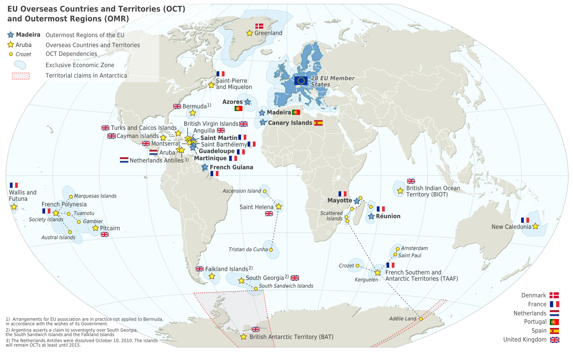
Deutsch: Karte der EU – Überseeische Länder und Hoheitsgebiete (OCT) und die Gebiete in äußerster Randlage (OMR). Diese Karte zeigt den räumlichen Geltungsbereich der Verträge der EU gemäß Artikel 52 des Vertrags über die Europäische Union und Artikel 355 des Vertrags über die Arbeitsweise der Europäischen Union.
Français : Carte de l’Union Européenne, en particulier les Pays et territoires d’outre-mer et les Régions ultrapériphériques. Cette carte montre la portée d’action territoriale des Traités de l’UE comme spécifié par l’Article 52 du Traité sur l’Union Européenne et l’Article 355 du Traité sur le Fonctionnement de l’Union Européenne.
English: Map of the EU – Overseas Countries and Territories (OCT) and Outermost Regions (OMR). This map shows the territorial scope of the Treaties of the EU as specified by Article 52 of the Treaty on European Union and Article 355 of the Treaty on the Functioning of the European Union. |
| తేదీ | |
| మూలం | Natural Earth 1:50m (http://www.naturalearthdata.com) |
| కర్త | Alexrk2 |
| ఇతర కూర్పులు |
|
![[ar] Arabic version \ النسخة العربية](http://commons.wikimedia.org/wiki/File:Map-Europe-Outermost-regions-ar.PNG)
![[de] German version / deutsche Version](http://commons.wikimedia.org/wiki/File:Map-Europe-Outermost-regions-de.png)
![[fr] French version / version français](http://commons.wikimedia.org/wiki/File:Map-Europe-Outermost-regions-fr.png)


|
This map has been made or improved in the German Kartenwerkstatt (Map Lab). You can propose maps to improve as well.
|
లైసెన్సింగ్
నేను, ఈ కృతి యొక్క కాపీహక్కుదారుని, దీన్ని ఈ లైసెన్సు క్రింద ఇందుమూలముగా ప్రచురిస్తున్నాను:
ఈ దస్త్రం క్రియేటివ్ కామన్స్ Attribution-Share Alike 3.0 Unported లైసెన్సు క్రింద లభ్యం.
- ఇలా చేసేందుకు మీకు స్వేచ్ఛ ఉంది:
- పంచుకోడానికి – ఈ కృతిని కాపీ చేసుకోవచ్చు, పంపిణీ చేయవచ్చు, ప్రసారమూ చేయవచ్చు
- రీమిక్స్ చేయడానికి – కృతిని అనుకరించడానికి
- క్రింది షరతులకు లోబడి:
- ఆపాదింపు – సముచితమైన శ్రేయస్సును ఇవ్వాలి, లైసెన్సుకు లింకు ఇవ్వాలి, మార్పులేమైనా చేస్తే వాటిని సూచించాలి. అందుకు సముచితమైన పద్ధతి దేన్నైనా అవలంబించవచ్చు. కానీ మీకూ మీ వాడుకకూ హక్కుదారు అనుమతించారు అనే అర్థం వచ్చేటట్లుగా మాత్రం కాదు.
- share alike – మీరు ఈ కృతిని అనుకరిస్తే, మారిస్తే, లేదా మెరుగుపరిస్తే తత్ఫలిత కృతిని ఇదే లైసెన్సు లేదా దీనికి అనుగుణ్యమైన లైసెన్సు క్రింద మాత్రమే పంపిణీ చేయాలి.
ఫైలు చరితం
తేదీ/సమయం ను నొక్కి ఆ సమయాన ఫైలు ఎలా ఉండేదో చూడవచ్చు.
| తేదీ/సమయం | నఖచిత్రం | కొలతలు | వాడుకరి | వ్యాఖ్య | |
|---|---|---|---|---|---|
| ప్రస్తుత | 06:14, 18 ఫిబ్రవరి 2024 | | 2,206 × 1,358 (1,003 KB) | Sqrt of 2 | Reverted to version as of 18:05, 12 June 2023 (UTC) |
| 16:08, 15 జనవరి 2024 |  | 2,206 × 1,358 (954 KB) | Multituberculata | Reverted to version as of 08:53, 31 May 2023 (UTC) | |
| 18:05, 12 జూన్ 2023 |  | 2,206 × 1,358 (1,003 KB) | DecafPotato | Reverted to version as of 14:48, 27 February 2019 (UTC) – The image includes UK territories, and was made prior to Brexit; please keep the UK in the map as part of the European Union for this reason | |
| 08:53, 31 మే 2023 |  | 2,206 × 1,358 (954 KB) | Iktsokh | Note | |
| 20:01, 21 మే 2023 |  | 2,206 × 1,358 (951 KB) | Iktsokh | Correction | |
| 09:56, 18 మే 2023 |  | 2,206 × 1,358 (950 KB) | Iktsokh | Updated | |
| 14:48, 27 ఫిబ్రవరి 2019 |  | 2,206 × 1,358 (1,003 KB) | Radom1967 | Reverted to version as of 17:02, 22 March 2018 (UTC). No need | |
| 12:13, 25 ఫిబ్రవరి 2019 |  | 2,206 × 1,358 (999 KB) | Odemirense | Countries with overseas regions in dark blue | |
| 17:02, 22 మార్చి 2018 |  | 2,206 × 1,358 (1,003 KB) | Maphobbyist | South Sudan border | |
| 18:24, 1 జనవరి 2014 |  | 2,206 × 1,358 (1 MB) | Alexrk2 | From 1 January 2014, the status of Mayotte will be that of an outermost region (COUNCIL DIRECTIVE 2013/61/EU of 17 December 2013) |
లింకులు
కింది పేజీలలో ఈ ఫైలుకు లింకులు ఉన్నాయి:
సార్వత్రిక ఫైలు వాడుక
ఈ దస్త్రాన్ని ఈ క్రింది ఇతర వికీలు ఉపయోగిస్తున్నాయి:
- ar.wiki.x.io లో వాడుక
- ast.wiki.x.io లో వాడుక
- azb.wiki.x.io లో వాడుక
- bn.wiki.x.io లో వాడుక
- ca.wiki.x.io లో వాడుక
- cs.wiki.x.io లో వాడుక
- en.wiki.x.io లో వాడుక
- Aruba
- Canary Islands
- Guadeloupe
- Martinique
- Mayotte
- Madeira
- Netherlands Antilles
- Réunion
- Overseas departments and regions of France
- Decolonisation of Africa
- History of colonialism
- Sint Maarten
- French Guiana
- User:Kazkaskazkasako/Books/All
- Caribbean Netherlands
- User:Tom29739/The EU
- User:Abyssal/bla
- List of colonies
- User:Falcaorib/World Alliances
- en.wikiquote.org లో వాడుక
- en.wikivoyage.org లో వాడుక
- es.wiki.x.io లో వాడుక
- fa.wiki.x.io లో వాడుక
- fi.wiki.x.io లో వాడుక
- gl.wiki.x.io లో వాడుక
- id.wiki.x.io లో వాడుక
- ilo.wiki.x.io లో వాడుక
- it.wiki.x.io లో వాడుక
- ka.wiki.x.io లో వాడుక
- mk.wiki.x.io లో వాడుక
ఈ దస్త్రపు మరింత సార్వత్రిక వాడుకను చూడండి.