దస్త్రం:Proposed states and territories of India.png
ఈ మునుజూపు పరిమాణం: 569 × 600 పిక్సెళ్ళు. ఇతర రిజల్యూషన్లు: 228 × 240 పిక్సెళ్ళు | 455 × 480 పిక్సెళ్ళు | 728 × 768 పిక్సెళ్ళు | 971 × 1,024 పిక్సెళ్ళు | 1,456 × 1,535 పిక్సెళ్ళు.
అసలు దస్త్రం (1,456 × 1,535 పిక్సెళ్ళు, ఫైలు పరిమాణం: 332 KB, MIME రకం: image/png)
This is a file from the Wikimedia Commons. Information from its description page there is shown below. Commons is a freely licensed media file repository. You can help. |

|
File:Proposed states and union territories of India.svg is a vector version of this file. It should be used in place of this PNG file when not inferior.
File:Proposed states and territories of India.png → File:Proposed states and union territories of India.svg
For more information, see Help:SVG. |
 |
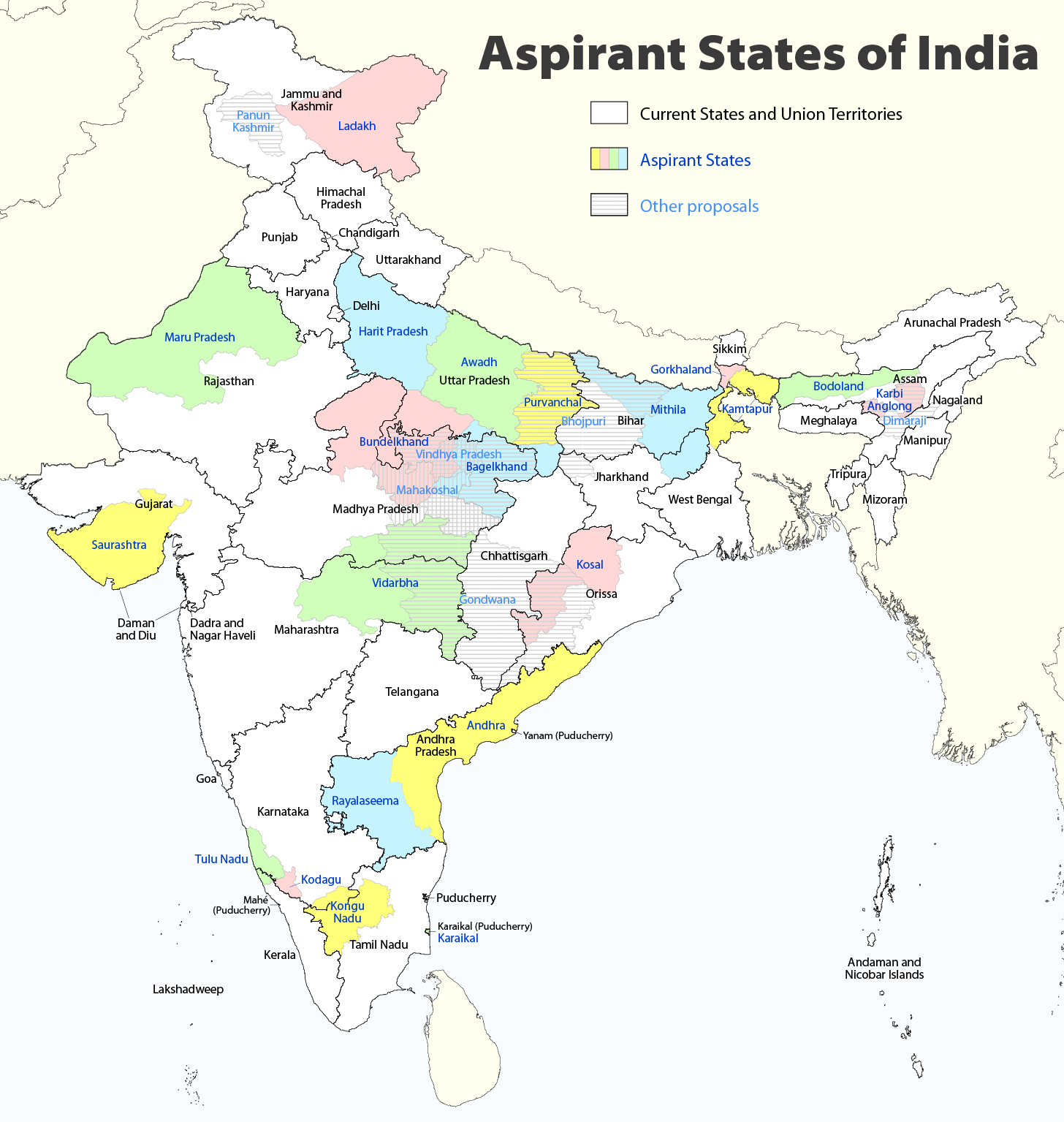
| వివరణ |
Deutsch: Indiens Anwärterstaaten
English: Aspirant States of India |
| తేదీ | |
| మూలం | స్వంత కృతి |
| కర్త | Maximilian Dörrbecker (Chumwa) |
| అనుమతి (ఈ దస్త్రాన్ని పునర్వినియోగించుకోవడం) |
నేను, ఈ కృతి యొక్క కాపీహక్కుదారుని, దీన్ని ఈ లైసెన్సు క్రింద ఇందుమూలముగా ప్రచురిస్తున్నాను: ఈ దస్త్రం క్రియేటివ్ కామన్స్ ఆపాదింపు-యథాతథ పంచుకోలు 2.5 సాధారణం లైసెన్సు క్రింద లభ్యం.
Sie dürfen das Bild zu den folgenden Bedingungen nutzen:
|
| ఇతర కూర్పులు |
|

ఫైలు చరితం
తేదీ/సమయం ను నొక్కి ఆ సమయాన ఫైలు ఎలా ఉండేదో చూడవచ్చు.
| తేదీ/సమయం | నఖచిత్రం | కొలతలు | వాడుకరి | వ్యాఖ్య | |
|---|---|---|---|---|---|
| ప్రస్తుత | 09:06, 2 ఆగస్టు 2020 | | 1,456 × 1,535 (332 KB) | Chumwa | Reverted to version as of 21:03, 29 August 2018 (UTC) |
| 20:03, 30 జూలై 2020 |  | 1,456 × 1,535 (316 KB) | UT'sIndia | Reverted to version as of 15:15, 17 May 2013 (UTC) | |
| 21:03, 29 ఆగస్టు 2018 |  | 1,456 × 1,535 (332 KB) | Chumwa | extended Tulu Nadu into Kerala | |
| 21:52, 5 జూన్ 2014 |  | 1,456 × 1,535 (332 KB) | Chumwa | borders of Rayalseema corrected | |
| 18:23, 3 జూన్ 2014 |  | 1,456 × 1,535 (332 KB) | Chumwa | borders of Mithila corrected | |
| 17:53, 3 జూన్ 2014 |  | 1,456 × 1,535 (331 KB) | Chumwa | Telangana now is an official state | |
| 15:16, 17 మే 2013 |  | 1,456 × 1,535 (316 KB) | Cromium | Removed large title; enlarged map key with slightly different wording | |
| 15:15, 17 మే 2013 |  | 1,456 × 1,535 (316 KB) | Cromium | Removed large title; enlarged map key with slightly different wording | |
| 22:32, 2 జనవరి 2012 |  | 1,456 × 1,535 (312 KB) | Chumwa | added some other aspirant states | |
| 21:16, 2 జనవరి 2012 |  | 1,456 × 1,535 (292 KB) | Chumwa | added a map key |
లింకులు
కింది పేజీలలో ఈ ఫైలుకు లింకులు ఉన్నాయి:
సార్వత్రిక ఫైలు వాడుక
ఈ దస్త్రాన్ని ఈ క్రింది ఇతర వికీలు ఉపయోగిస్తున్నాయి:
- bn.wiki.x.io లో వాడుక
- de.wiki.x.io లో వాడుక
- en.wiki.x.io లో వాడుక
- Delhi
- Gondwana (India)
- Kodagu district
- Mithila (proposed Indian state)
- Awadh
- Vidarbha
- Bundelkhand
- Bagelkhand
- Tulu Nadu
- Rayalaseema
- Purvanchal
- Bodoland Territorial Region
- Karbi Anglong district
- Mahakoshal
- Kongu Nadu
- Cooch Behar district
- Gird, India
- Mara Autonomous District Council
- Tripura Tribal Areas Autonomous District Council
- Malabar District
- Gorkhaland movement
- Kamtapur
- Proposed states and union territories of India
- Autonomous administrative divisions of India
- Karaikal district
- Panun Kashmir
- Chakma Autonomous District Council
- Lai Autonomous District Council
- Khasi Hills Autonomous District Council
- Jaintia Hills Autonomous District Council
- Garo Hills Autonomous District Council
- Template:Proposed states and union territories of India
- Tulu Nadu state movement
- Kosal state movement
- User:AbhisheksinghWIKI/Law and Order(India)
- Gorkhaland Territorial Administration
- Tipraland
- Kalyana-Karnataka
- Sadar Hills
- West Karbi Anglong district
ఈ దస్త్రపు మరింత సార్వత్రిక వాడుకను చూడండి.