దస్త్రం:Puducherry Map.svg

ఈ ఫైలు SVG కు చెందిన ఈ మునుజూపు PNG పరిమాణం: 514 × 600 పిక్సెళ్ళు. ఇతర రిజల్యూషన్లు: 206 × 240 పిక్సెళ్ళు | 411 × 480 పిక్సెళ్ళు | 658 × 768 పిక్సెళ్ళు | 877 × 1,024 పిక్సెళ్ళు | 1,755 × 2,048 పిక్సెళ్ళు | 1,486 × 1,734 పిక్సెళ్ళు.
అసలు దస్త్రం (SVG ఫైలు, నామమాత్రంగా 1,486 × 1,734 పిక్సెళ్ళు, ఫైలు పరిమాణం: 783 KB)
This is a file from the Wikimedia Commons. Information from its description page there is shown below. Commons is a freely licensed media file repository. You can help. |
సారాంశం
| వివరణ |
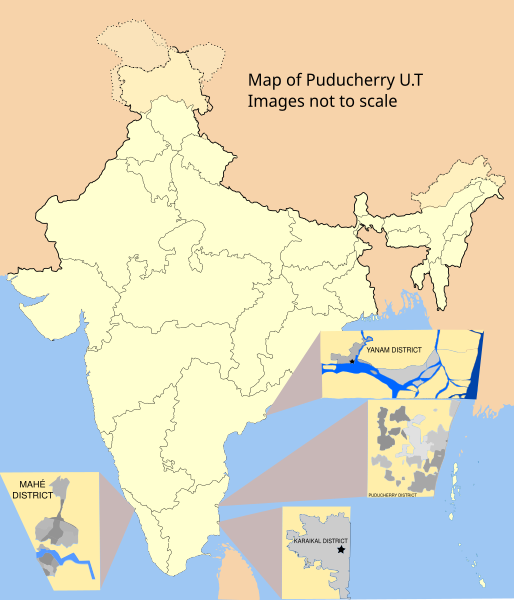
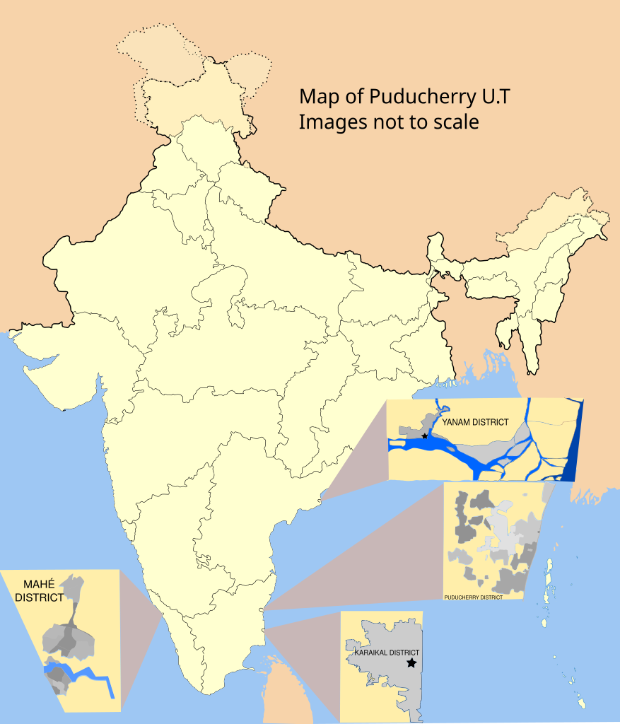
English: Map showing the four districts of the Union Territory of Puducherry, India.
Uses File:India-locator-map-blank.svg as a base. District maps recreated from the following raster images File:മയ്യഴി.png - vectorised File:Karikal 1-126720 58N-NE 1920s.jpg - Hand traced File:Manavely.png - vectorised File:Yanaon_1932.jpg - Hand traced |
| తేదీ | |
| మూలం | స్వంత కృతి |
| కర్త | RaviC |

|
Attribution information, such as the author's name, e-mail, website, or signature, that was once visible in the image itself has been moved into the image metadata and/or image description page. This makes the image easier to reuse and more language-neutral, and makes the text easier to process and search for. Commons discourages placing visible author information in images.
|
లైసెన్సింగ్
నేను, ఈ కృతి యొక్క కాపీహక్కుదారుని, దీన్ని ఈ లైసెన్సు క్రింద ఇందుమూలముగా ప్రచురిస్తున్నాను:
ఈ దస్త్రం క్రియేటివ్ కామన్స్ Attribution-Share Alike 3.0 Unported లైసెన్సు క్రింద లభ్యం.
- ఇలా చేసేందుకు మీకు స్వేచ్ఛ ఉంది:
- పంచుకోడానికి – ఈ కృతిని కాపీ చేసుకోవచ్చు, పంపిణీ చేయవచ్చు, ప్రసారమూ చేయవచ్చు
- రీమిక్స్ చేయడానికి – కృతిని అనుకరించడానికి
- క్రింది షరతులకు లోబడి:
- ఆపాదింపు – సముచితమైన శ్రేయస్సును ఇవ్వాలి, లైసెన్సుకు లింకు ఇవ్వాలి, మార్పులేమైనా చేస్తే వాటిని సూచించాలి. అందుకు సముచితమైన పద్ధతి దేన్నైనా అవలంబించవచ్చు. కానీ మీకూ మీ వాడుకకూ హక్కుదారు అనుమతించారు అనే అర్థం వచ్చేటట్లుగా మాత్రం కాదు.
- share alike – మీరు ఈ కృతిని అనుకరిస్తే, మారిస్తే, లేదా మెరుగుపరిస్తే తత్ఫలిత కృతిని ఇదే లైసెన్సు లేదా దీనికి అనుగుణ్యమైన లైసెన్సు క్రింద మాత్రమే పంపిణీ చేయాలి.
ఫైలు చరితం
తేదీ/సమయం ను నొక్కి ఆ సమయాన ఫైలు ఎలా ఉండేదో చూడవచ్చు.
| తేదీ/సమయం | నఖచిత్రం | కొలతలు | వాడుకరి | వ్యాఖ్య | |
|---|---|---|---|---|---|
| ప్రస్తుత | 12:16, 1 మార్చి 2021 | | 1,486 × 1,734 (783 KB) | RaviC | updated spellings // Editing SVG source code using c:User:Rillke/SVGedit.js |
| 15:08, 10 జూన్ 2019 |  | 1,486 × 1,734 (783 KB) | Gazoth | Removed attribution watermark | |
| 18:59, 10 జూన్ 2014 |  | 1,486 × 1,734 (784 KB) | RaviC | fix text issue | |
| 16:34, 10 జూన్ 2014 |  | 1,486 × 1,734 (796 KB) | RaviC | User created page with UploadWizard |
లింకులు
కింది పేజీలలో ఈ ఫైలుకు లింకులు ఉన్నాయి:
సార్వత్రిక ఫైలు వాడుక
ఈ దస్త్రాన్ని ఈ క్రింది ఇతర వికీలు ఉపయోగిస్తున్నాయి:
- ar.wiki.x.io లో వాడుక
- bn.wiki.x.io లో వాడుక
- ceb.wiki.x.io లో వాడుక
- el.wiki.x.io లో వాడుక
- en.wiki.x.io లో వాడుక
- fa.wiki.x.io లో వాడుక
- ha.wiki.x.io లో వాడుక
- he.wiki.x.io లో వాడుక
- hi.wiki.x.io లో వాడుక
- mai.wiki.x.io లో వాడుక
- ml.wiki.x.io లో వాడుక
- ne.wiki.x.io లో వాడుక
- no.wiki.x.io లో వాడుక
- sat.wiki.x.io లో వాడుక
- simple.wiki.x.io లో వాడుక
- skr.wiki.x.io లో వాడుక
- sq.wiki.x.io లో వాడుక
- sv.wiki.x.io లో వాడుక
- ta.wiki.x.io లో వాడుక
- ur.wiki.x.io లో వాడుక