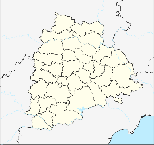
దస్త్రం:Telangana locator map.svg

ఈ ఫైలు SVG కు చెందిన ఈ మునుజూపు PNG పరిమాణం: 537 × 508 పిక్సెళ్ళు. ఇతర రిజల్యూషన్లు: 254 × 240 పిక్సెళ్ళు | 507 × 480 పిక్సెళ్ళు | 812 × 768 పిక్సెళ్ళు | 1,082 × 1,024 పిక్సెళ్ళు | 2,165 × 2,048 పిక్సెళ్ళు.
అసలు దస్త్రం (SVG ఫైలు, నామమాత్రంగా 537 × 508 పిక్సెళ్ళు, ఫైలు పరిమాణం: 1.82 MB)
ఫైలు చరితం
తేదీ/సమయం ను నొక్కి ఆ సమయాన ఫైలు ఎలా ఉండేదో చూడవచ్చు.
| తేదీ/సమయం | నఖచిత్రం | కొలతలు | వాడుకరి | వ్యాఖ్య | |
|---|---|---|---|---|---|
| ప్రస్తుత | 05:16, 6 జూలై 2020 |  | 537 × 508 (1.82 MB) | Arjunaraoc | Reverted to version as of 11:00, 17 April 2019 (UTC) |
| 05:41, 28 జూన్ 2020 |  | 443 × 443 (227 KB) | C1MM | Fixed Krishna river delta | |
| 19:49, 3 జూన్ 2020 |  | 443 × 443 (227 KB) | C1MM | Increased district boundary size, fixed unjoined district boundary | |
| 03:49, 5 మే 2020 |  | 443 × 443 (229 KB) | C1MM | Fixed colors | |
| 19:10, 22 ఏప్రిల్ 2020 |  | 443 × 443 (229 KB) | C1MM | Fixed border colors | |
| 17:10, 16 ఏప్రిల్ 2020 |  | 443 × 443 (229 KB) | C1MM | Changed colors and boundaries to be smaller | |
| 22:04, 14 ఏప్రిల్ 2020 |  | 537 × 508 (242 KB) | C1MM | Made lake standard | |
| 05:44, 12 ఏప్రిల్ 2020 |  | 537 × 508 (242 KB) | C1MM | Changed district boundaries and re-did layering | |
| 14:34, 22 మార్చి 2020 |  | 537 × 508 (1.81 MB) | C1MM | Added standard colors and made borders prominent | |
| 11:00, 17 ఏప్రిల్ 2019 |  | 537 × 508 (1.82 MB) | Arjunaraoc | Updated with Telangana districts as vector layer |
లింకులు
కింది పేజీలలో ఈ ఫైలుకు లింకులు ఉన్నాయి:
- ఆదిలాబాద్ జిల్లా
- ఇలేగాం
- ఖమ్మం జిల్లా
- గంగదేవిపల్లి
- తిప్పడంపల్లి కోట
- నల్గొండ జిల్లా
- నిజామాబాదు జిల్లా
- మెదక్ జిల్లా
- రంగారెడ్డి జిల్లా
- సికింద్రాబాద్
- హనుమకొండ జిల్లా
- హైదరాబాదు జిల్లా
- వాడుకరి:Ch Maheswara Raju/సమాచారపెట్టెలు
- వాడుకరి:K.Venkataramana/సమాచారపెట్టెలు
- వాడుకరి:వైజాసత్య/ఇసుకపెట్టె4
- వాడుకరి:వైజాసత్య/ఇసుకపెట్టె4/doc
- వికీపీడియా చర్చ:వికీప్రాజెక్టు/పటములు
- మూస:Location map Telangana
- మూస:Telangana locator map
- మూస:భారత స్థల సమాచారపెట్టె
- మూస:భారత స్థల సమాచారపెట్టె/doc
సార్వత్రిక ఫైలు వాడుక
ఈ దస్త్రాన్ని ఈ క్రింది ఇతర వికీలు ఉపయోగిస్తున్నాయి:
- azb.wiki.x.io లో వాడుక
- حئیدرآباد (هیندوستان)
- علیآباد، رنقا ردی
- عبداللهپور
- عالمپور، محبوبنقار
- معینآباد، مندال
- ونوقوپالپورام
- وانام واری کریشناپورام
- ساتیانارایاناپورام
- ساروپالی, نالقوندا دیستریکت
- ساروارام
- سارانقاپور, جاقتیال دیستریکت
- مدارام
- سانقام, وارانقال دیستریکت
- کالشوارام
- مارور, نالقوندا دیستریکت
- ونکپالی
- ماریقودم
- ماریقودا
- مارپال
- مارکوک, تلانقانا
- ماریپدا
- ولولا (هیندوستان)
- کایسارام
- ولماکان
- ولقاتور
- ولپور (هیندوستان)
- واسانتاپورام
- وارشاکوندا
- سایداپور
- مانواریپامپو
- کادتال
- موست آباد
- کاداورقو
- شامش آباد
- سولیپور
- کاداپارتی
- رودرارام
- مانقاپت
- مانقالپالی, نالقوندا دیستریکت
- مانقالاقودم
- کئی. آر. پورام (تلانقانا)
- جوکال, ایندیا
- ماندالاپورام
- آنانتارام, نالقوندا ماندال
- آنانتارام, مداک دیستریکت
- آنانتارام, شامیرپت ماندال
- آنانتارام, بونجیر ماندال
- رمیدیچرلا
- آناجپور
- جینارام
ఈ దస్త్రపు మరింత సార్వత్రిక వాడుకను చూడండి.